Property Record
5324 Five Forks Trickum Rd Sw, Lilburn, GA 30047
NEARBY LISTINGS FOR SALE OR LEASE
Property Detail
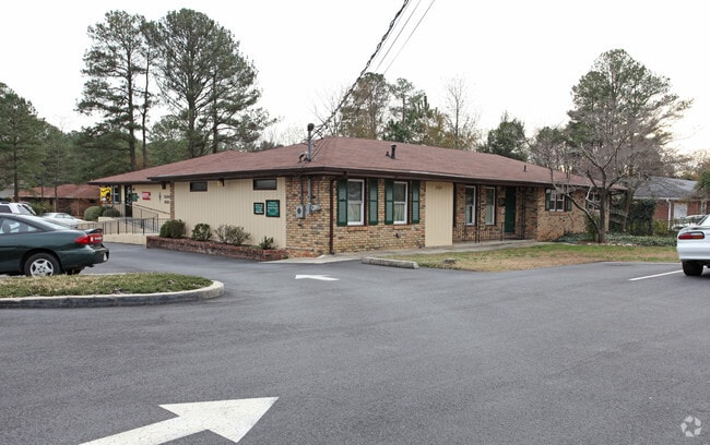
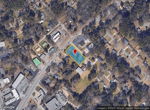
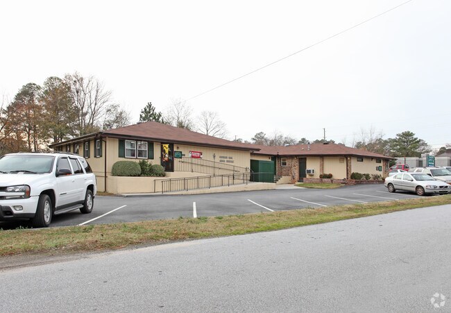
5324 Five Forks Trickum Rd Sw
Atlanta-Sandy Springs-Roswell, GA
Five Forks Trickum Rd
6-079-018
FIVE FORKS TRICKUM RD
Animalhospitalvet
Gwinnett
X
Georgia
13089C0084K
79
2025
0.74 AC
2025
Lawrenceville/Lilburn
050430
Atlanta
4,744 SF
DEMOGRAPHICS near 5324 Five Forks Trickum Rd Sw
1 Mile
3 Mile
5 Mile
2024 Total Population
6,882
46,635
184,829
2029 Population
7,150
48,322
189,639
Pop Growth 2024-2029
+ 3.89%
+ 3.62%
+ 2.60%
Average Age
40
41
38
2024 Total Households
2,289
15,798
62,835
HH Growth 2024-2029
+ 3.93%
+ 3.56%
+ 2.47%
Median Household Inc
$102,826
$93,593
$68,408
Avg Household Size
3.00
2.90
2.90
2024 Avg HH Vehicles
2.00
2.00
2.00
Median Home Value
$358,159
$325,487
$280,349
Median Year Built
1980
1981
1984
Nearby Places
Map Layers
Map Styles
 Street
 Aerial
- Restaurants
- Banks
- Shops
- Fitness
- Groceries
PUBLIC TRANSPORTATION
AIRPORT
Hartsfield - Jackson Atlanta International
DRIVE
WALK
Distance
Hartsfield - Jackson Atlanta International
41 min
27.0 mi
Nearby Properties
Address
Land Use
TOTAL SIZE
Lot Size
Zoning
Address
Land Use
TOTAL SIZE
Lot Size
Zoning
Address
Land Use
TOTAL SIZE
Lot Size
Zoning
2,682,168 SF
80.24 AC
M1
Address
Land Use
TOTAL SIZE
Lot Size
Zoning
301,646 SF
23.90 AC
RM13
Address
Land Use
TOTAL SIZE
Lot Size
Zoning
232,617 SF
19.61 AC
RM
Address
Land Use
TOTAL SIZE
Lot Size
Zoning
307,313 SF
15.60 AC
RM24
Address
Land Use
TOTAL SIZE
Lot Size
Zoning
388,696 SF
13.89 AC
RM100
Address
Land Use
TOTAL SIZE
Lot Size
Zoning
339,612 SF
38.64 AC
C2
Address
Land Use
TOTAL SIZE
Lot Size
Zoning
526,306 SF
77.45 AC
R100
Address
Land Use
TOTAL SIZE
Lot Size
Zoning
335,605 SF
20.22 AC
RM100
Address
Land Use
TOTAL SIZE
Lot Size
Zoning
180,940 SF
11.78 AC
M1
Address
Land Use
TOTAL SIZE
Lot Size
Zoning
179,784 SF
6.57 AC
C2
Address
Land Use
TOTAL SIZE
Lot Size
Zoning
208,590 SF
26.01 AC
C2
Address
Land Use
TOTAL SIZE
Lot Size
Zoning
111,729 SF
6.67 AC
C2
Address
Land Use
TOTAL SIZE
Lot Size
Zoning
80,014 SF
9.73 AC
R100
Address
Land Use
TOTAL SIZE
Lot Size
Zoning
229,095 SF
14.10 AC
M1
Address
Land Use
TOTAL SIZE
Lot Size
Zoning
106,114 SF
16.59 AC
C2
Address
Land Use
TOTAL SIZE
Lot Size
Zoning
89,686 SF
18.29 AC
C2
Address
Land Use
TOTAL SIZE
Lot Size
Zoning
110,588 SF
8.89 AC
C2
Address
Land Use
TOTAL SIZE
Lot Size
Zoning
135,406 SF
14.10 AC
C2
Address
Land Use
TOTAL SIZE
Lot Size
Zoning
123,980 SF
11.50 AC
M1
Address
Land Use
TOTAL SIZE
Lot Size
Zoning
88,892 SF
7.50 AC
M1
Address
Land Use
TOTAL SIZE
Lot Size
Zoning
80,310 SF
4.92 AC
C2
Address
Land Use
TOTAL SIZE
Lot Size
Zoning
52,262 SF
6.02 AC
C3
Address
Land Use
TOTAL SIZE
Lot Size
Zoning
87,415 SF
8.14 AC
M
Address
Land Use
TOTAL SIZE
Lot Size
Zoning
98,336 SF
6.98 AC
C2
Address
Land Use
TOTAL SIZE
Lot Size
Zoning
140,226 SF
17.12 AC
C2
Address
Land Use
TOTAL SIZE
Lot Size
Zoning
62,377 SF
6.42 AC
OI
Address
Land Use
TOTAL SIZE
Lot Size
Zoning
63,000 SF
3.40 AC
M1
Address
Land Use
TOTAL SIZE
Lot Size
Zoning
78,382 SF
14.53 AC
RM100
Address
Land Use
TOTAL SIZE
Lot Size
Zoning
63,136 SF
4.65 AC
M1
The World's #1 Commercial Real Estate Marketplace
Connect with us
© 2026 CoStar Group
The information above has been obtained from sources believed reliable. While we do not doubt its accuracy we have not verified it and make no guarantee, warranty or representation about it. It is your responsibility to independently confirm its accuracy and completeness. Any projections, opinions, assumptions, or estimates used are for example only and do not represent the current or future performance of the property. The value of this transaction to you depends on tax and other factors which should be evaluated by your tax, financial, and legal advisors. You and your advisors should conduct a careful, independent investigation of the property to determine to your satisfaction the suitability of the property for your needs.